That You Were Never The Same?
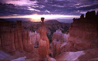
Kodachrome Basin State Park

Photo: Travel Utah
A Medley of Colors and Sandstone Wonders
Kodachrome Basin State Park is renowned for its breathtaking sandstone formations and vivid landscapes. It is tucked among southern Utah’s colorful canyon country just east of Bryce National Park. The park covers approximately 2,240 acres of otherworldly terrain that photographers, hikers and nature enthusiasts find irresistible.
Located just nine miles south of Cannonville and State Route 12, the park’s evocative title reflects the astonishing range of colors that change dramatically depending on the time of day and season. It was given its name in 1949 by the National Geographic Society with special permission from Kodak.
Its towering sand pipes, sculpted by natural forces over millions of years, dominate the landscape giving visitors a unique glimpse into geological history.
One Theory of How Kodachrome Basin Came To Be
Geologists suggest that Kodachrome Basin was once similar to Yellowstone National Park with its numerous hot springs and geysers. Over countless years, these geysers filled with sediment and gradually solidified into dense sandstone columns.
As softer Entrada sandstone eroded away, the solidified geyser pipes … some as tall as 170 feet … were left standing forming the stunning natural chimneys seen today. These geological remnants, known as sand pipes, are rare and fascinating features. They make Kodachrome Basin one of the most distinctive parks in Utah.
At Kodachrome, you’ll find:
- overnight camping facilities
- drinking water
- modern rest rooms
- hot showers and a sewage disposal station
- hiking trails
- guided horseback riding
- mountain biking

Scenic and Photographic Opportunities
Kodachrome Basin State Park is a paradise for photographers. Its array of reds, oranges, yellows, whites and browns contrasts vividly with Utah's deep blue skies and the seasonal greenery that punctuates the landscape.
Sunrise and sunset hours provide extraordinary lighting illuminating sandstone formations and creating unforgettable images. Visitors regularly pause to capture another stunning moment as the colors shift dramatically throughout the day.
We happened to be there in the middle of a sunny day so didn’t have the benefit of great lighting for taking photographs.
Trails and Hiking Adventures
Kodachrome Basin boasts several well-marked trails catering to all skill level, from leisurely strolls to more challenging hikes. Each trail showcases unique rock formations and scenic overlooks that ensure a rewarding experience.
- Panorama Trail (3 miles round-trip) - A moderately easy loop, this trail features landmarks like the distinctive "Ballerina Slipper" formation. It is also suitable for mountain biking as it offers exceptional views and varied scenery.
- Eagle's View Trail (¾ mile each way) - Short but steep, this trail rewards hikers with a spectacular panoramic overlook of the colorful basin and surrounding countryside.
- Shakespeare Arch Trail (¼ mile each way) - A short, easy walk leading visitors directly to Shakespeare Arch which is a naturally formed sandstone arch. It is a great choice for families or visitors looking for an easier yet picturesque stroll.
- Angel's Palace Trail (½ mile loop) - Easy and rewarding, Angel’s Palace offers elevated viewpoints overlooking the picturesque basin below. Ideal for photographers or casual hikers.
- Grand Parade Trail (1-mile loop) - A moderate trail that intertwines through the heart of the park. It provides close-up views of sand pipes and vibrant rock formations.
- Big Bear Geyser/Cool Cave Trail (2 miles round-trip) - An extension of the Panorama Trail, this moderate trail leads hikers past uncommon formations like the Big Bear Geyser pipe and Cool Cave adding some intrigue to an already memorable hike.

Photo: Travel Utah
Additional Recreational Opportunities
Besides hiking, visitors can enjoy mountain biking along selected trails, horseback riding in designated areas and off-highway vehicle adventures just outside park boundaries. Nearby attractions include Bryce Canyon National Park, Grosvenor Arch and the rugged beauty of Paria Canyon. Kodachrome Basin is an excellent focal point for exploring the entire region.
We drove through Kodachrome Basin State Park as we were headed east and then eventually north on Scenic Byway 12 after visiting Bryce Canyon National Park. It is 20 miles or about a half hour southeast of Bryce.
It sits at 5,800 feet above sea level but the terrain drops off precipitously from the 8,500-9,000 feet that Bryce Canyon sits at up on the plateau. We were headed north to Escalante and beyond but still spent some time driving around the park. We took some photos despite the harsh midday lighting.
We were there in May and the temperatures were ideal. It was a sunny day with temperatures in the mid to high 60º F range. Temperatures will reach the 80’s in July but due to the altitude, they don’t get as extreme as you might expect for as far south as it is.

Photo: Travel Utah
Camping and Park Facilities
Kodachrome Basin State Park offers a comfortable and welcoming campground featuring:
- Modern restrooms with hot showers
- Drinking water
- A sewage disposal station for RV convenience
- Picnic areas
Both standard campsites and group campsites are available, accommodating everything from single-family stays to larger gatherings.
For current campsite availability, rates, and reservations, visitors are encouraged to visit the official "Travel America" website.
Visitor Center & How To Get To Kodachrome
Located conveniently within the park, the Visitor Center provides travelers with essentials such as food, snacks, water, ice and camping supplies. Like many of Utah’s State Parks, staff is available to answer questions, provide trail maps and suggest activities based on individual interests.
Kodachrome Basin State Park is located about 22 miles southeast of Bryce Canyon National Park. To reach the park from there, travel southeast west on Scenic Byway 12 to Tropic and then on to Cannonville. Then head south on the paved section of Kodachrome Rd/Main Street and follow for 9 miles.
Coming from any other direction, you’re still going to be heading to Cannonville and using the same road to the park. Highway 12 along this section roughly shadows the Paria River and is a very scenic drive as well.

Park Information and Fees
- Park Size: Approximately 2,240 acres
- Operating Hours: Open year-round, 6:00 AM to 10:00 PM daily (no holiday closures)
- Day-Use and Camping Fees: For current day-use and camping fees, please refer to
the official Utah State Parks website. Rates seem to change on an annual
basis. Every time I list these rates, they become obsolete quickly.
- Reservations: Campsite and group-site reservations can be made through the Travel America reservation system. Early booking is recommended especially during peak season.
- Activities: Hiking, photography, mountain biking, camping, horseback riding (designated areas), wildlife viewing, scenic drives and nearby off-road adventures.
Kodachrome
Basin State Park
P.O. Box 238
Cannonville, Utah 84718-0238
Phone: (435) 679-8562
Website: Kodachrome Basin State Park
Have A Great Story About One of Utah's State Parks?


Bryce Canyon National Park

Canyonlands National Park

Wasatch Mountains

Lake Powell

Zion National Park

Arches National Park

Great Salt Lake

Monument Valley